Origins and History

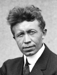
Vilhjalmur Stefansson, above, was an early 20th Century explorer from Canada who became best known for spending a year living with the indigenous peoples inhabiting Inuit Nunangat, the Arctic regions of Greenland, Canada, and Alaska. He is generally accepted to be the first person to identify the Arctic Pole of Inaccessibility in his writings for the Geographical Review (Vol. 10, No.3 (Sept, 1920), pp.167-172).
Drawing circles of 500-mile radius, he defined an area where the arcs intersected and called it a zone of “comparative inaccessibility” and identifying that “any point within it is less accessible than the North Pole”. Drawing Isochronic lines from the position of three ships – Peary, berry and Nansen – he defined the “pole of inaccessibility”, describing the Pole as “the point within the arctic regions most difficult to access for any explorer who first goes as far as he can by ship and then pushes forward by the use of men and dogs hauling sledges.”
After Stefansson’s definition, the term became widely used in reference to exploration of the Antarctic (Petrov 1959). Explorers used the same methodology to identify the point in the Antarctic furthest from the sea – the Antarctic Pole of Inaccessibility.
In more recent times a study by Daniel Garcia-Castellanos and Umberto Lombardo in the Scottish Geographical Journal used a similar methodology and took to describing Poles of Inaccessibility as the “location furthest from a particular coastline” and as “the places on Earth that are furthest from any Ocean”. They presented an algorithm to calculate the spots furthest from the sea in major land masses and tabulated data for six of the The Eight Poles: Antarctica, Africa, North America, South America, Australia, and Eurasia as well as Great Britain, Greenland, Iberia, Madagascar and Point Nemo.
In 2019, Chris Brown has extended the concept of PIAs even further to define the Point of Inaccessibility to be the point furthest from any border (as opposed to Sea).