Florida
The Point of Inaccessibility for Florida lies in marshland belonging to the Avon Park Air Force Range, on the eastern shores of Lake Arbuckle in Polk County, between Seebring and Lake Wales
The exact location of the Florida PIA is determined to be at:
- Latitude: 27° 41.495’ N
- Longitude: 81° 22.944’ W
- Distance from sea: 54.2 miles
These coordinates were calculated by Miso for Chris Brown in July 2019.
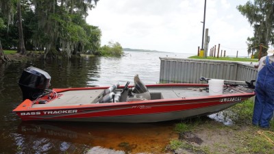
Location of the Florida Point of Inaccessibility
This point is in marshland on a military installation, thus inaccessible to members of the public. You can, however, get pretty close…
You’ll be able to use a regular car to access the lake, but of course you’ll need a boat to go any further or be a very brave and experienced open-water swimmer. In the absence of a boat, we’d recommend a six-pack of beer (seriously) as an incentive for one of the local boat owners to take you to the pole.
Getting to the Florida Pole
Date Visited: 16th July, 2019
Visited by: Chris Brown, Axel Brown & Robert
Weather: 32 Celsius/89 Fahrenheit. Few clouds and very humid.
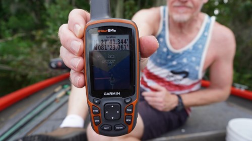
Coordinates Achieved: N 27°41.344, W 81°23.061’
Distance from Pole: Approximately 300m
Axel and I drove a 4×4 for approximately 2.5 hours from Cocoa Beach near Orlando to the northernmost shore of Lake Arbuckle. Starting out on Interstate 95, we turned onto Route 60 and then Highway 630E. Nearing the location, we took Blue Jordan Road and turned off onto Lake Reedy Boulevard, going round the south of that lake. The final turn towards Lake Arbuckle was onto Lake Arbuckle Road which turned into Old Frostproof Road.
Maps were showing what looked like dirt tracks (hence the SUV) to within around 500m of the POI. Our plan was get as close as possible by vehicle and then wind our way through the trees to the exact location.
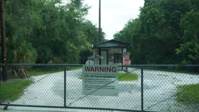
Unfortunately just as you arrive at the north of the lake, and where the metaled road turns into a track, the route is barred as the PIA seems to be situated on American Air Force land. The route is blocked by a fence and unmanned gatehouse.
It was time for Plan B; a waterborne approach.
Immediately on the right as the road runs out is a ‘hunting, shooting and fishing’ campsite apparently quite popular in the deer-shooting season. We had hoped to be able to hire a boat if there were any recreational facilities there. But as we entered the site, it became apparent that this was really quite a remote area. We could see a couple of RVs and a caravan, but no people. Then, luckily, we spotted one gentleman at the side of the lake filleting fish. A fisherman; surely he had a boat!
Robert was naturally wary of two obvious soft-skinned outsiders disturbing his peace. Nevertheless, he gave us the time of day and listened with interest as to why we’d burst on to the scene. Soon he was warming to the idea that his local lake was a ‘special place’.
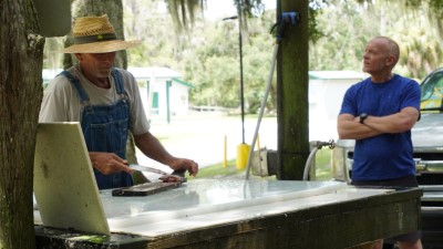
“Well I’m not saying I couldn’t use the money,” he said when I offered to make the trip out onto the water worth his while, “but I’ve got this bucket of Blue Fins to finish up. They go off in the heat”. We assured him that there really was no rush with us having traveled so far to get to this point, and from then on we were in business.
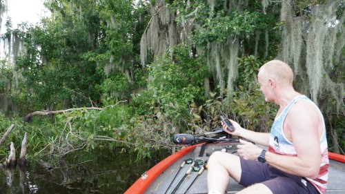
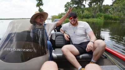
At the tenth time of asking, a little cussing and a lift of the motors, the little red boat fired up and we headed out onto the lake. The weather was hot and humid with little wind. Robert informed us it wasn’t uncommon for strong winds to get up on Lake Arbuckle, coming in at 5 or 6 miles per hour at the south but reaching 20 mph by the north.
On the maps you could see the PIA is near a point where the shoreline juts out slightly. So, it is no surprise that this area is shallow, with vegetation on the surface that had to be navigated. Luckily the boat had a depth indicator to assist with local knowledge. “Well I’ll be darned!” exclaimed Robert – the POI turns out to be close to one of his regular fishing haunts.
After a couple of about-turns we approached the PIA to within around 150m. But that next section, whilst not entirely impossible, would be hard going to say the least. Apart from officially being on military land, the PIA is in 4 foot deep, dense marshland as you can see from this picture, and alligators have been spotted close by – “big ones,” says Robert. We didn’t inquire as to how big, because any ‘gator is enough to deter us softies.
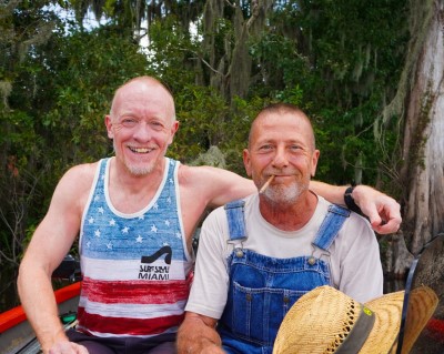
Back at the campsite we joined Robert for a drink at his caravan. He likes to get up there a couple of times a month for a few days each time. He does little other than fish, sit and think – enjoying the solitude and surroundings. He’s married, but we got the feeling his trips are appreciated by both sides. Not having a smartphone himself (“You touch something and it goes all dark and starts doing strange things you don’t want it to do”), he gave us his wife’s number to send photos of the day’s trip. Will she know who they are coming from? “No,” he declared. “I want her to ask.”
Robert (‘Bobby’ is apparently reserved for only the closest of friends, and he prefers for his surname not to appear on the internet) worked in the local correctional facility, or prison, until his recent retirement. His specialty was being on the Search Squad with an enviable reputation for being able to sniff out a shank or drugs before the dogs got there. Sadly he now walks slowly with a limp having damaged his back falling from a ladder doing DIY in his retirement. This being America, there is no free healthcare and he can’t afford to get it sorted.
- See also: North American Pole of Inaccessibility